July 25-26, 2014
Map (link)*
Day 1, July 25
E Fork Blacktail Deer Cr TH to below Honeymoon Park
When I first moved to Missoula back in 2003, the first thing I remember buying, before anything else, was a guide book called Hiking Montana. I'd already worked at Glacier Park two years earlier and knew it pretty well, but I had no idea about the rest of the state. I had that book read cover to cover in a matter of days and all sorts of plans were hatched to check out all of these wonderful areas, now so close to my new home. Of course, I was especially drawn to the usual renowned areas: the Bitterroots and Rattlesnake right in my backyard; the vast Bob Marshall and the steep, rugged Missions just to the north; the Beartooths, home to Montana's highest point, Granite Peak; the Absarokas and Spanish Peaks rising to the north of Yellowstone Park. For years, as I've planned and executed my summer backpacks, these places have always taken precedent. Strangely though, it seems like every time I flipped through that guide book, I always found myself stopping to read the description of a hike the author simply calls "Snowcrest."
I must say that the author has nothing but fine things to say about this 23 mile loop through an area that very few people would ever think to access on their own, and maybe that was part of what kept me so intrigued. What really piqued my interest though, was the idea of an 11 mile stroll along a 10,000 foot ridgeline in a part of the state that I'd never been near before. At any rate, after years of passing it up in favor of other trips, it was finally time to check this place out.
My primary concerns on this one were thunderstorms and drinking water. Fortunately, the forecast wasn't calling for any rain for days, so I was optimistic on that front. Water was its own issue though. Even this early in the season, my only source on the ridge would be snowmelt. Unless I wanted a dry camp, my first night's resting place would have to be just below the ridge, only about 5 miles in. Good news was that I didn't have to rush out of town this morning in order to make that goal. In the end, after grabbing last minute supplies in Dillon and driving the 40 miles of dirt roads to the trailhead, I didn't even get on my way until just after 5:00. Fortunately, the trail was mild and the scenery was interesting enough as I made my way up the drainage. After a couple hours of pleasant strolling, I found a nice spot with a great view of the entire ridge that I planned on traversing tomorrow. Then, I cooked a nice meal before relaxing and enjoying the changing light on Stonehouse Mountain as I ate. When the last bit of pink faded out, I headed for the tent. I'm not sure that it was even completely dark when I fell asleep.
Day 2, July 26
Honeymoon Park to TH
Today was quite a day. It didn't go exactly as planned, but then I guess they never really do. Given my early bedtime last night, I had no problem rising before the sun this morning. I knew I had a ways to go, so breakfast was quick. After packing up, I filled four liters of water and set out for the ridge and my intersection with the Snowcrest Divide trail. Turns out, I was closer than I thought. After only about 10 minutes of walking, I'd reached the junction. So began the long ridgewalk that had kept me intrigued for all these years.
Here, the trail all but disappeared, instead marked by posts and ridiculous cairns for miles and miles. Fortunately, routefinding was incredibly easy, as often times, the entire route was visible. Even if it wasn't, when in doubt, I could just stick to the ridgeline and look for the next cairn.
Once I'd gained the ridge, I could see for days. Very interesting views from up here. I got my first ever look at the Lima Peaks and the Centennial Divide to the south, two ranges that are certainly notable, but rarely mentioned in any of the literature I've come across. Beyond them, partially obscured by the early smoke this year, I could just make out the Grand Tetons. To the North and East, I had a nice look at the Madison and Tobacco Root Ranges, both of which I am familiar with, though not from this vantage. Honestly, they held most of my attention as I ascended along the ridge toward Stonehouse Mountain (named, reasonably enough, for a little stone house that a shepherd built on his flanks some time ago).
I reached the summit around 11:00 and decided to enjoy an early lunch. The longer views out to the many different ranges around me were slowly disappearing into the thickening haze. Not to worry though, as I was enjoying the look down into the Blacktail Deer Creek basin more than anything else by this point anyway. In fact, I was beginning to realize what made this hike so interesting. Whereas most backpacking loops tend to circumnavigate a single major mountain or range by way of linking basins, this one does the exact opposite. I was walking all the way around this basin on the ridgeline above it. The funny thing is, I was just as focused on the basin I was circling as I usually am on that centerpiece mountain or range. Even with views in all directions, it held most of my attention.
After a long relaxing lunch at the summit, it was time to continue on. From here, it was just a whole lot of moderately paced ups and downs as I linked giant cairns along the gentle, wide open, wildflower strewn ridge.
Eventually, when the route turned back to the west, I got a nice view down into Peterson Basin, my original plan for a home tonight. It was still early though, and I just wasn't ready to get down from here yet. On top of that, I really didn't find it all that appealing anyway (though it looked like moose and deer and elk would disagree with me on that one). At any rate, I decided to stay up high and continue along on the ridgeline for another couple miles before dropping down onto the the Lawrence Creek trail, which would take me back toward the trailhead.
These last couple miles went too quickly, and I was forced to say goodbye to ridgeline country. I begrudgingly began my descent in the direction of the trail, which I only found after a few miles of wandering along the route that it appeared to follow on my map. This was still very pretty country though, and I danced my way through more wildflowers as I descended near the creek.
I easily could have spent another night right here, but once again, it was still very early and I knew I was only a couple hours from the trailhead. I decided I needed a nice break to think about it. That's when the flies showed up again. I'd been struggling somewhat with these guys all day long. Even on the ridge, I didn't have a whole lot of wind to keep them at bay, so walking and swatting became my general method of defense. Fortunately, they only came and went, and I had wonderful views and an agenda to keep me at ease when they were around. Now, if I were to stay here, I'd likely just find myself hiding in the tent until the temperature dropped enough to send them down for the night. Not really the way I wanted to spend the rest of the day. The decision was made and I reached the car a couple hours later. I threw my pack in the back and got on the road as fast as possible. I drove like a bat out of hell, but was handsomely rewarded when I reached the taco bus in Dillon about a half hour before they closed. After gorging on the best Mexican food in all of Montana, I was back on the road and headed for Missoula.
* For some reason, ACME Mapper keeps jumbling up the waypoints when I link to maps. Hopefully, the route is still discernible given the above description.
Map (link)*
 | |
| One of the many giant cairns along the Snowcrest Divide |
Day 1, July 25
E Fork Blacktail Deer Cr TH to below Honeymoon Park
When I first moved to Missoula back in 2003, the first thing I remember buying, before anything else, was a guide book called Hiking Montana. I'd already worked at Glacier Park two years earlier and knew it pretty well, but I had no idea about the rest of the state. I had that book read cover to cover in a matter of days and all sorts of plans were hatched to check out all of these wonderful areas, now so close to my new home. Of course, I was especially drawn to the usual renowned areas: the Bitterroots and Rattlesnake right in my backyard; the vast Bob Marshall and the steep, rugged Missions just to the north; the Beartooths, home to Montana's highest point, Granite Peak; the Absarokas and Spanish Peaks rising to the north of Yellowstone Park. For years, as I've planned and executed my summer backpacks, these places have always taken precedent. Strangely though, it seems like every time I flipped through that guide book, I always found myself stopping to read the description of a hike the author simply calls "Snowcrest."
I must say that the author has nothing but fine things to say about this 23 mile loop through an area that very few people would ever think to access on their own, and maybe that was part of what kept me so intrigued. What really piqued my interest though, was the idea of an 11 mile stroll along a 10,000 foot ridgeline in a part of the state that I'd never been near before. At any rate, after years of passing it up in favor of other trips, it was finally time to check this place out.
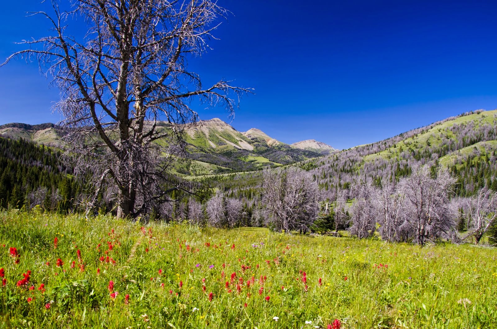
My primary concerns on this one were thunderstorms and drinking water. Fortunately, the forecast wasn't calling for any rain for days, so I was optimistic on that front. Water was its own issue though. Even this early in the season, my only source on the ridge would be snowmelt. Unless I wanted a dry camp, my first night's resting place would have to be just below the ridge, only about 5 miles in. Good news was that I didn't have to rush out of town this morning in order to make that goal. In the end, after grabbing last minute supplies in Dillon and driving the 40 miles of dirt roads to the trailhead, I didn't even get on my way until just after 5:00. Fortunately, the trail was mild and the scenery was interesting enough as I made my way up the drainage. After a couple hours of pleasant strolling, I found a nice spot with a great view of the entire ridge that I planned on traversing tomorrow. Then, I cooked a nice meal before relaxing and enjoying the changing light on Stonehouse Mountain as I ate. When the last bit of pink faded out, I headed for the tent. I'm not sure that it was even completely dark when I fell asleep.
 | |
| Stonehouse Mountain |
Day 2, July 26
Honeymoon Park to TH
Today was quite a day. It didn't go exactly as planned, but then I guess they never really do. Given my early bedtime last night, I had no problem rising before the sun this morning. I knew I had a ways to go, so breakfast was quick. After packing up, I filled four liters of water and set out for the ridge and my intersection with the Snowcrest Divide trail. Turns out, I was closer than I thought. After only about 10 minutes of walking, I'd reached the junction. So began the long ridgewalk that had kept me intrigued for all these years.
 | |
| Sunset and Olson Peaks from near Honeymoon Park |
Here, the trail all but disappeared, instead marked by posts and ridiculous cairns for miles and miles. Fortunately, routefinding was incredibly easy, as often times, the entire route was visible. Even if it wasn't, when in doubt, I could just stick to the ridgeline and look for the next cairn.
 | ||
| A sea of lupine and the first giant cairn |
Once I'd gained the ridge, I could see for days. Very interesting views from up here. I got my first ever look at the Lima Peaks and the Centennial Divide to the south, two ranges that are certainly notable, but rarely mentioned in any of the literature I've come across. Beyond them, partially obscured by the early smoke this year, I could just make out the Grand Tetons. To the North and East, I had a nice look at the Madison and Tobacco Root Ranges, both of which I am familiar with, though not from this vantage. Honestly, they held most of my attention as I ascended along the ridge toward Stonehouse Mountain (named, reasonably enough, for a little stone house that a shepherd built on his flanks some time ago).
 |
| The stone house, complete with a nice fire pit in the front yard |
 | |
| En route to Stonehouse Mountain |
I reached the summit around 11:00 and decided to enjoy an early lunch. The longer views out to the many different ranges around me were slowly disappearing into the thickening haze. Not to worry though, as I was enjoying the look down into the Blacktail Deer Creek basin more than anything else by this point anyway. In fact, I was beginning to realize what made this hike so interesting. Whereas most backpacking loops tend to circumnavigate a single major mountain or range by way of linking basins, this one does the exact opposite. I was walking all the way around this basin on the ridgeline above it. The funny thing is, I was just as focused on the basin I was circling as I usually am on that centerpiece mountain or range. Even with views in all directions, it held most of my attention.
 | ||
| Looking down Blacktail Deer Creek from the summit of Stonehouse Mountain |
After a long relaxing lunch at the summit, it was time to continue on. From here, it was just a whole lot of moderately paced ups and downs as I linked giant cairns along the gentle, wide open, wildflower strewn ridge.
 |
| Linking cairns on the wide open ridge. The next one can be seen in the distance on the next high point. |
 |
| More lupine and open ridgeline strolling |
 | |
| Looking back to the north |
 | |
| My standard view for most of the day |
Eventually, when the route turned back to the west, I got a nice view down into Peterson Basin, my original plan for a home tonight. It was still early though, and I just wasn't ready to get down from here yet. On top of that, I really didn't find it all that appealing anyway (though it looked like moose and deer and elk would disagree with me on that one). At any rate, I decided to stay up high and continue along on the ridgeline for another couple miles before dropping down onto the the Lawrence Creek trail, which would take me back toward the trailhead.
These last couple miles went too quickly, and I was forced to say goodbye to ridgeline country. I begrudgingly began my descent in the direction of the trail, which I only found after a few miles of wandering along the route that it appeared to follow on my map. This was still very pretty country though, and I danced my way through more wildflowers as I descended near the creek.
 |
 | |
| Sunset Peak from the vicinity of the Lawrence Creek trail |
I easily could have spent another night right here, but once again, it was still very early and I knew I was only a couple hours from the trailhead. I decided I needed a nice break to think about it. That's when the flies showed up again. I'd been struggling somewhat with these guys all day long. Even on the ridge, I didn't have a whole lot of wind to keep them at bay, so walking and swatting became my general method of defense. Fortunately, they only came and went, and I had wonderful views and an agenda to keep me at ease when they were around. Now, if I were to stay here, I'd likely just find myself hiding in the tent until the temperature dropped enough to send them down for the night. Not really the way I wanted to spend the rest of the day. The decision was made and I reached the car a couple hours later. I threw my pack in the back and got on the road as fast as possible. I drove like a bat out of hell, but was handsomely rewarded when I reached the taco bus in Dillon about a half hour before they closed. After gorging on the best Mexican food in all of Montana, I was back on the road and headed for Missoula.
* For some reason, ACME Mapper keeps jumbling up the waypoints when I link to maps. Hopefully, the route is still discernible given the above description.